Corps of Discovery · 1804–1806
Corps of Discovery Expedition
President Jefferson sent them into 8,000 miles of unmapped wilderness. Thirty-three men. One mission. What they brought back changed the country forever.
Click any entry to expand the full account — journal entries quoted verbatim.
On a rainy Monday morning, 33 men pushed off from Camp Dubois into the Missouri River. Clark commanded the 55-foot keelboat carrying weapons, medicine, scientific instruments, and nearly a ton of gifts intended for Native nations. Lewis watched from shore and rejoined downstream after finishing last-minute business in St. Louis.
Jefferson's instructions had been exact: map the rivers, catalogue every plant and animal, make peaceful contact with every tribe, and find a water route to the Pacific. Nobody in Washington knew how far that route was — or whether it existed. Most of the men had never been west of the Mississippi.
"I set out at 4 oClock P.M. in the presence of many of the neighbouring inhabitants, and proceeded on under a jentle breese up the Missourie."
— William Clark · May 14, 1804Library of Congress / Wikimedia Commons — Public Domain
Lewis and Clark held their first formal meeting with Native American leaders on a shaded hill above the Missouri. Representatives of the Otoe and Missouria nations listened to Lewis's prepared speech announcing American sovereignty over the land. The speech was translated through three languages, losing nuance at every step.
The chiefs accepted Jefferson Peace Medals — silver coins with Jefferson's face on one side and clasped hands on the other. What they privately made of the American claim to land their people had lived on for generations is not recorded in the journals. This diplomatic template would be repeated at dozens of councils across the continent.
Sergeant Charles Floyd died — almost certainly from a ruptured appendix, untreatable anywhere in the world in 1804. Lewis, trained by Dr. Benjamin Rush, did everything possible. Floyd was buried on a bluff with full military honors; Clark named the nearby creek after him.
Remarkably, Floyd would be the only Corps member to die on the entire 28-month, 8,000-mile journey — an extraordinary record for a wilderness expedition of 33 people.
"Died with a great deel of Composure, haveing Said to me before his death that he was going away and wished me to write a letter &c."
— William Clark · August 20, 1804The Teton Sioux were the most powerful nation on the northern plains. When warriors grabbed the rope of a pirogue and demanded a boat as tribute, Lewis ordered the cannon aimed at shore. Clark drew his sword. Thirty armed Sioux stood their ground. For several long minutes, neither side moved.
Then Chief Black Buffalo stepped forward, ordered his warriors back, and released the rope. Lewis and Clark recorded it as the most dangerous moment they had faced. They were right.
"I felt My Self warm & Spoke in very positive terms… The chiefs were not satisfied, haiveing every expectation of reciving goodes."
— William Clark · September 25, 1804The Corps built Fort Mandan near the Mandan and Hidatsa villages on the upper Missouri. Temperatures dropped to -40°F. During this winter they met Toussaint Charbonneau — a French-Canadian trapper living with the Hidatsa — and his wife Sacagawea, a Shoshone woman kidnapped from her tribe as a child.
The Corps hired Charbonneau specifically for Sacagawea's Shoshone language skills, which they needed to negotiate horses for the mountain crossing ahead. The decision would save the expedition.
Sacagawea gave birth to her first child in the cold of Fort Mandan, Lewis assisting the difficult delivery. The boy, Jean Baptiste Charbonneau, was nicknamed "Pomp" by Clark, who later took personal responsibility for his education.
Two months later, Pomp left Fort Mandan strapped to his mother's back and traveled the entire remaining journey to the Pacific and home — a 6,000-mile round trip before his first birthday. The youngest member of the Corps by roughly twenty years.
"Sah-cah-gah-wea our Indian woman was delivered of a fine boy… it is worthy of remark that this was the first child which this woman had boarn."
— Meriwether Lewis · February 11, 1805Lewis heard the roar before he saw it. The Great Falls of the Missouri — five cascades spanning 18 miles — were completely impassable by canoe. Native informants had described a portage of half a day. The reality was eighteen days of hauling boats over rocky terrain in blazing heat through prickly pear cactus that shredded their moccasins.
Lewis's specially designed iron-frame boat failed completely — the elk-hide covering split. They abandoned it and cut new canoes from cottonwood trees. The eighteen-day delay pushed the mountain crossing dangerously close to winter.
"I beheld those mountains with the most pleasureable sensation… the grandest sight I ever beheld."
— Meriwether Lewis · June 13, 1805Lewis had crossed the Continental Divide ahead of the main party and found a band of Shoshone. When Sacagawea arrived to translate, she recognized the chief: it was her brother, Cameahwait — she had been kidnapped as a child and hadn't seen her family in years.
The reunion transformed everything. Cameahwait provided 29 horses, a Shoshone guide named Old Toby, and detailed route information. Without this encounter — which Lewis called "a most affecting scene" — the Corps could not have obtained the horses needed to cross the Rockies before winter.
"She instantly jumped up, and ran and embraced him, throwing her blanket over him and crying profusely."
— Meriwether Lewis · August 17, 1805The Lolo Trail nearly ended everything. September snowstorms, temperatures below freezing, terrain so steep the horses fell. No game anywhere. The men ate their horses one by one, then boiled the tallow candles. Men who had survived a Sioux standoff and an 18-day portage were now stumbling in snow too weak to lift their packs.
Clark pushed ahead to find help. The Nez Perce fed the starving Corps and sent food back. The crossing took eleven brutal days. This — not the standoff, not the falls — was when the expedition most nearly failed.
"I have been wet and as cold in every part as I ever was in my life, indeed I was at one time fearfull my feet would freeze."
— William Clark · September 16, 1805Clark wrote five words, underlined three, misspelled one. It didn't matter. After 4,000 miles and eighteen months, the Corps of Discovery had reached the Pacific Ocean. Every man standing on that bank was the furthest west any U.S. citizen had ever documented standing.
The celebration was brief. They still had to survive a Pacific winter and make the 4,000-mile return home. But for that one rainy evening on the Oregon shore, they let themselves feel the full weight of what they had done.
"Ocian in view! O! the joy."
— William Clark · November 7, 1805Lewis and Clark put the winter camp location to a vote. Every member cast a ballot — including York, who was enslaved, and Sacagawea, a Native American woman. This vote happened 60+ years before the 15th Amendment and 115 years before women's suffrage.
Historians consider this one of the earliest documented instances of democratic inclusion in American history. Clark recorded Sacagawea's vote under the name "Janey." Her choice: a location near wapato root. It was counted alongside every other man's ballot.
It rained or was heavily foggy on all but 12 of their 106 days at Fort Clatsop. Fleas were relentless. Food was monotonous — elk and more elk, frequently spoiled. Nearly everyone suffered from respiratory illness and infections. And yet Lewis and Clark produced more scientific documentation that winter than at almost any other point in the journey.
The Corps arrived in St. Louis to crowds and cannon fire. Most of America had assumed they were dead. Lewis immediately sent a letter to Jefferson: they had done it. Each soldier received double pay and 320 acres of land. Charbonneau received $500.
York, who had paddled, carried, hunted, and voted alongside every other man for 28 months, received nothing — he remained enslaved. Sacagawea received nothing. Their contributions were acknowledged in words. Not in law.
"The party are all attached to their native homes and wish much to See their parents once more… they intend to return to the Illinois to pass the winter."
— Meriwether Lewis · September 23, 1806Soldiers, frontiersmen, an interpreter, an enslaved man, and a Shoshone woman with her infant son.
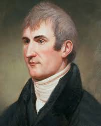
1774–1809 · Age 29 at departure
Who He WasJefferson's personal secretary and a U.S. Army captain. Jefferson spent months training him in botany, celestial navigation, medicine, and natural science before departure. Intense, meticulous, brilliant — and prone to dark moods that worsened severely after the expedition ended.
His RoleThe expedition's primary scientist. He documented every new species with detailed descriptions and drawings, took astronomical readings to fix geographic position, managed diplomatic encounters, and wrote long, lyrical journal entries that remain among the finest nature writing in early American literature.
His ImportanceLewis's scientific journals became the foundation of western American natural history. He died in 1809 at age 35, likely by his own hand, before his journals were fully published. His pressed plant specimens are still preserved at Philadelphia's Academy of Natural Sciences — 220 years later.
Portrait: Charles Willson Peale, c. 1807 — Independence National Historical Park / Wikimedia Commons
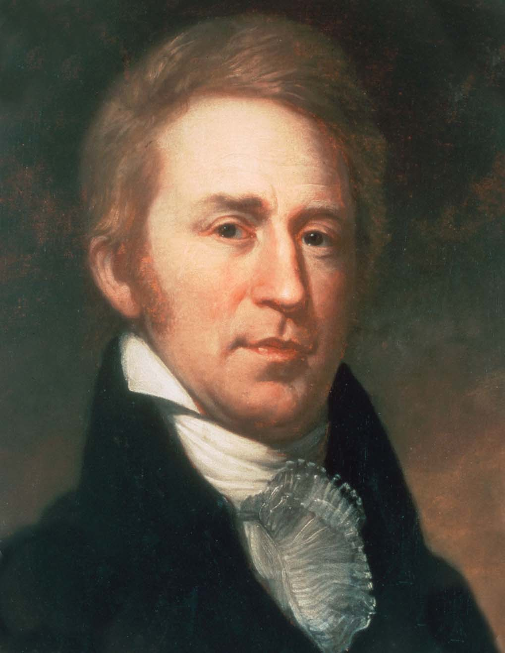
1770–1838 · Age 33 at departure
Who He WasA former Army officer and Lewis's close friend. Where Lewis was intense, Clark was steady. The men loved him. Native leaders respected him. A natural commander who kept the Corps functioning through the most brutal months — and a notoriously poor speller who mapped the continent with startling accuracy.
His RoleClark made the maps — 140 of them. Detailed charts of rivers, mountain passes, and geography that didn't exist anywhere before. He also managed day-to-day operations, discipline, and navigated the keelboat through currents that nearly capsized them multiple times.
His ImportanceClark's maps were the most immediately useful output of the expedition. Explorers, traders, and settlers used them for decades. After the journey, he served as Superintendent of Indian Affairs and Governor of Missouri Territory until his death at age 68.
Portrait: Charles Willson Peale, c. 1807–1808 — Independence National Historical Park / Wikimedia Commons
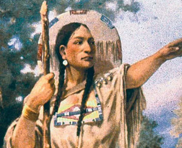
c. 1788–1812 · Age ~16 at departure
Who She WasA Shoshone woman kidnapped by the Hidatsa as a child. The Corps hired Charbonneau specifically for her language skills — they needed a Shoshone interpreter. She joined the expedition while pregnant and traveled the entire journey with her infant son strapped to her back.
Her RoleHer practical contributions were enormous. She translated with the Shoshone, securing 29 horses for the Rockies crossing. She identified edible plants — camas root, wapato, bitterroot — that saved them from starvation multiple times. Her presence as a woman with a nursing infant served as a living peace signal at every tribe they encountered.
Her ImportanceWithout the horses she helped obtain from her brother, the Corps could not have crossed the Continental Divide. She received no compensation. Today she appears on the U.S. dollar coin — an acknowledgment, however late.
E.S. Paxson mural, Montana State Capitol / Wikimedia Commons
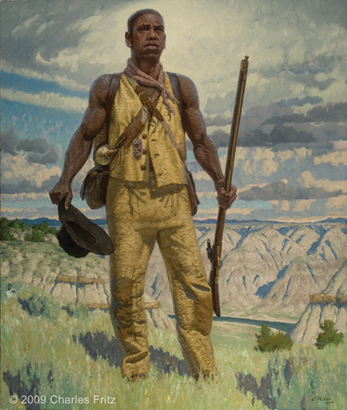
c. 1775–c. 1832 · Age ~29 at departure
Who He WasAn enslaved man owned by William Clark. He had grown up alongside Clark and participated fully in every aspect of the journey — from hunting to carrying loads through the mountains. He was large, powerful, and capable.
His RoleYork played a complete physical role in the expedition. His presence fascinated many Native peoples who had never seen a Black man, creating diplomatic openings the Corps used to advantage. At Fort Clatsop he voted in the democratic deliberation on where to build the winter camp — alongside free white men, as if he were equal. Legally, he was property.
His ImportanceYork served as a full Corps member, earned respect from Lewis, Clark, and Native peoples — then received nothing. No land. No pay. He remained enslaved for years after the journey. Clark eventually freed him around 1815. He is believed to have died of cholera around 1832. His story is the expedition's hardest truth.
1775–c. 1817 · Age ~29 at departure
Who He WasA New Hampshire-born Army sergeant — one of the most trusted non-commissioned officers. Reliable, disciplined, and literate. He wrote a journal entry without exception for every single day of the 28-month journey — the only Corps member to do so.
His Role & ImportanceOrdway frequently commanded independent detachments when the party split. Lewis purchased his journal for $300 — the only journal he bought from any Corps member — recognizing its completeness as irreplaceable. For the days when Lewis and Clark themselves wrote nothing, Ordway's entries are the only surviving record of what happened.
Purchased August 1803 · $20
Who He WasLewis's large Newfoundland dog, bought in Pittsburgh for $20 — roughly $500 today. At roughly 150 pounds, Newfoundlands are built for cold water and loyalty. Seaman appears in over 40 journal entries, more than most humans on the expedition. Lewis clearly loved him.
Why He MattersSeaman retrieved shot game from rivers, warned the camp of approaching animals, and was once stolen — Lewis immediately dispatched three armed men to retrieve him. He represents something important: the expedition was a human journey. The men cared about their dog. That humanity is worth remembering alongside the science and diplomacy.
Eight thousand miles across 13 present-day states — on foot, horse, and canoe.
Interactive map — click markers for details. © OpenStreetMap contributors / CARTO · Leaflet.js
Jefferson had three interconnected goals. First: find a navigable water route to the Pacific — the mythic "Northwest Passage." Second: establish diplomatic and commercial relations with every Native nation in the Louisiana Territory. Third: conduct a complete scientific survey of the land's plants, animals, and geography.
He also had a political goal he didn't state openly: countering British and Spanish influence in the region. The Louisiana Purchase gave the U.S. the land on paper. Having Americans cross it, map it, and make diplomatic contact made the claim real.
On April 30, 1803, the U.S. paid France $15 million for 828,000 square miles of territory — roughly 3 cents per acre. It doubled the country overnight.
Napoleon sold because his plans for a western hemisphere empire had collapsed when Haiti won its independence. Jefferson moved immediately — before the purchase was even finalized, he was planning the expedition.
What nearly stopped them — and how they kept going.
The Lolo Trail through Idaho's Bitterroot Mountains is brutal even in summer. The Corps entered it in September 1805 with the first snowstorms already rolling in. They expected a five-day crossing. They got eleven days of near-vertical terrain, temperatures below freezing, and a complete absence of game. Nothing to eat in the mountains at all.
They slaughtered and ate their horses one by one. Then boiled and ate tallow candles. Men who had survived a Missouri River flood, a Sioux standoff, and an 18-day portage were now stumbling in snow, too weak to lift their packs. Clark described the range as "the most terrible mountains I ever beheld."
Shoshone guide Old Toby knew the trail. On the western slope, the Nez Perce chose to feed the starving Corps and care for their horses through the winter. Without Nez Perce generosity — extended to unknown armed strangers — the Corps would not have survived.
The Teton Sioux controlled the upper Missouri and had legitimate reasons to resist American claims to their territory. When warriors grabbed the rope of a pirogue and demanded a boat as tribute, Lewis ordered the cannon aimed at shore. Clark drew his sword. Thirty armed Sioux stood their ground. A single wrong movement would have ended the expedition.
Chief Black Buffalo stepped forward, ordered his warriors back, and released the rope. The Corps moved upriver quickly. The underlying conflict — American expansion into Sioux territory — was not resolved. It simply paused.
Native informants described a portage of half a day. What they found were five cascades spanning 18 miles — and an 18-day portage through prickly pear cactus that destroyed their moccasins. Temperature swung between 100°F heat and violent hailstorms. Lewis's specially designed iron-frame boat failed completely when the elk-hide covering split.
They abandoned the boat, built crude wooden wagons, dragged everything overland, and cut new dugout canoes from cottonwood trees. The 18-day delay pushed the mountain crossing dangerously close to the early winter that nearly killed them in the Bitterroots.
The Corps dealt with illness constantly. Sergeant Floyd died of a ruptured appendix in August 1804 — untreatable anywhere in 1804. Most men suffered repeatedly from intestinal illness, infected boils, and respiratory infections. On the return journey, Lewis was accidentally shot in the buttock by a nearsighted Corps member who mistook him for an elk.
Lewis had trained with Dr. Benjamin Rush — one of America's foremost physicians — and carried a fully stocked medicine chest. Sacagawea's knowledge of medicinal plants supplemented his training. Only Floyd died — an extraordinary record for a 28-month wilderness expedition of 33 people.
On the Great Plains the men consumed up to 9 pounds of meat per day. But in the mountains, game disappeared entirely. They ate horses, ate candles, ate anything that could sustain them. Lewis once watched 10,000 bison from the riverbank — a wildlife abundance that would be gone within 80 years. In the mountains there was nothing.
Sacagawea's knowledge of edible plants — camas root, wapato, bitterroot — saved lives multiple times. The Mandan, Nez Perce, and Chinook fed the Corps at pivotal moments, often out of genuine generosity. Without Native hospitality the expedition would not have returned.
What they found — and why it mattered to a young nation trying to understand itself.
Lewis documented 178 plant species unknown to Western science — the bitterroot (Montana's state flower, Lewisia rediviva), clarkia (named for Clark), Lewis's monkeyflower, ponderosa pine, and dozens of plants used medicinally by Native peoples. He collected physical specimens, pressed them, drew detailed illustrations, and wrote precise botanical descriptions for each one.
The largest single contribution to American botany in the 19th century. Lewis's pressed specimens are still held at Philadelphia's Academy of Natural Sciences. Source: Cutright, Lewis and Clark: Pioneering Naturalists.
The Corps documented 122 animals new to science: the pronghorn antelope (fastest land animal in the Western Hemisphere), the grizzly bear, the prairie dog, the black-tailed deer, the western meadowlark, Clark's nutcracker, Lewis's woodpecker, and many more. Lewis sent a live prairie dog to Jefferson — it survived the months-long overland journey.
Several species still carry the names Lewis and Clark assigned. The grizzly encounters alone transformed American understanding of North American wildlife. Source: Cutright.
Clark produced 140 maps of the expedition's route — the most comprehensive cartographic survey of the American interior ever made. These charts accurately depicted the Missouri River system, the Rocky Mountains, the Columbia watershed, and the Pacific coastline. The 1810 compilation map became the definitive picture of the American West for a generation.
Clark's maps directly enabled the Oregon Trail and American settlement of the Pacific coast. Source: Allen, Passage Through the Garden.
Jefferson's central hope was a short navigable river route directly connecting the Missouri to the Pacific. Lewis and Clark definitively proved this was impossible. The Rocky Mountains were not a single manageable ridge but a massive, multi-hundred-mile barrier. No water route could exist. This was a profound disappointment — and one of the expedition's most important findings.
Disproving the Northwest Passage myth forced American planners to design westward expansion around overland routes — and ultimately the transcontinental railroad. Source: Jackson, Thomas Jefferson & the Stony Mountains.
Lewis and Clark made formal contact with over 50 Native nations, recording their languages, customs, populations, and territorial boundaries. They distributed Jefferson Peace Medals, announced American sovereignty over the Louisiana Territory, and invited tribal leaders to Washington. Lewis's notes on Native languages were among the first records of many of these tongues.
The U.S. government's first serious effort to know the peoples of the West. This information shaped — and ultimately harmed — American-Native policy for generations. Source: Ronda, Lewis and Clark Among the Indians.
Lewis and Clark maintained extraordinarily detailed journals throughout — weather, geography, astronomy, plant and animal life, Native cultures, river depths. Together they run to millions of words across multiple volumes. Clark's entries track daily mileage with meticulous precision. Lewis's landscape descriptions are some of the finest nature writing in early American literature.
Published in 1814, the journals are a foundational scientific document. For ecologists studying pre-settlement western ecology, they remain irreplaceable. Source: Moulton, ed., Journals of the Lewis and Clark Expedition, 13 vols., Univ. of Nebraska Press.
Before 1804, the American West was a blank space — unmapped, unstudied, heavily mythologized. The Louisiana Purchase gave the U.S. the land on paper; Lewis and Clark made it real. They replaced speculation with knowledge, blank spaces with rivers and mountain passes and named peoples and documented species.
The scientific discoveries proved the $15 million cost of the Louisiana Purchase was worth it many times over. The geographic knowledge enabled the fur trade, the Oregon Trail, and ultimately the settlement of the Pacific coast. And the expedition itself became a story — of two men, a baby, a dog, and thirty others who went into the unknown and came back with something that has lasted 220 years.
Lewis and Clark did not travel through empty wilderness. They crossed a continent of nations.
The Corps of Discovery's survival depended — completely, and at multiple critical moments — on the knowledge, generosity, and guidance of Native peoples. The continent the expedition crossed was home to dozens of sophisticated nations who had lived in, managed, and known this land for thousands of years. Lewis and Clark's own journals acknowledge this repeatedly, even as the political mission they carried was one of American expansion into territory the U.S. had no real right to claim.
Large, prosperous earth-lodge villages along the upper Missouri. Experienced farmers and skilled traders who dealt with European fur trappers for decades. They welcomed the Corps for winter 1804–1805, providing food, shelter, and critical geographic intelligence about the route west.
Sacagawea's people. When the Corps reached them in August 1805, the remarkable coincidence of Sacagawea recognizing the chief as her brother transformed a cautious diplomatic meeting into an emotional family reunion. Chief Cameahwait provided 29 horses, a guide, and detailed route information.
The Nez Perce met the Corps as they stumbled out of the Bitterroots in September 1805, starving and barely able to walk. Despite holding every advantage over the weakened group, they chose to feed them, help build canoes, and care for their horses through the winter.
The most powerful nation on the northern plains, the Teton Sioux controlled access to the upper Missouri and had legitimate reasons to resist American claims. The September 1804 standoff — guns drawn, cannon loaded — was the closest the Corps came to open battle.
Sophisticated traders who had dealt with European ships for years before Lewis and Clark arrived. They drove hard commercial bargains and knew their market value. They provided food and survival knowledge during the difficult Oregon winter. The Corps spent five months near their villages at Fort Clatsop.
Recipients of the first formal council in August 1804. Lewis gave his prepared speech announcing American sovereignty and distributed Jefferson Peace Medals. The chiefs listened and accepted the gifts. What they privately made of the American claim to their land is not recorded in the journals — only the American side of the conversation survives.
How a 28-month expedition reshaped a nation — and why historians still argue about it.
The expedition's maps and journals made westward expansion practically possible. Within a generation, fur trappers, missionaries, and settlers were following Clark's maps into the territory. The Oregon Trail, developed in the 1840s, largely followed the route Lewis and Clark had charted. The expedition proved the continent could be crossed — creating the psychological and practical foundation for Manifest Destiny.
By 1860, Americans had settled Oregon, California, and the Great Plains. An expansion that might have taken decades longer without the knowledge Lewis and Clark provided. In this sense, the expedition is the direct ancestor of America's Pacific coast communities — for better and worse.
The plant specimens Lewis collected are still housed at Philadelphia's Academy of Natural Sciences, 220 years later. The animals he described are still known by the names he assigned. His geographic observations influenced naturalists and geologists for a century after his death.
For ecologists studying what the American West looked like before industrial transformation, Lewis and Clark's journals are irreplaceable primary sources. They documented a continent in its pre-industrial state — what animals lived where, how the rivers ran, what the grasslands held — with a precision never replicated.
Lewis and Clark's physical presence on the Pacific coast gave the United States its most credible claim to the Pacific Northwest. When Britain and the U.S. disputed ownership of the Oregon Territory in the 1840s, American diplomats pointed to the expedition as evidence of prior American presence. The 1846 Oregon Treaty awarded the U.S. everything below the 49th parallel — present-day Oregon, Washington, and Idaho.
Lewis and Clark's impact on Native peoples is genuinely complicated. They treated most Native nations with more curiosity and respect than was typical of their era. But their mission — claiming sovereignty over Native land for the United States — set in motion the policies that would ultimately destroy those nations' ways of life.
The fur trade they opened brought disease and ecological destruction. The settlers who followed brought wars and forced removal. Understanding both sides is why historians still study this expedition — it contains the best and worst of American expansion in the same story.
Two hundred and twenty years after their departure, Lewis and Clark remain among the most studied events in American history. The reason isn't simply that it was a remarkable physical achievement — it's that the expedition sits at the intersection of almost every major theme in American history simultaneously.
Race and democracy: York voted in 1805, sixty-plus years before the 15th Amendment. Gender: Sacagawea was essential to the expedition's survival, compensated nothing, and acknowledged seriously only in recent decades. Ecology: the journals are primary sources for a lost pre-industrial world. Diplomacy: fifty nations, fifty complex relationships, one American claim to sovereignty over land that was not the U.S. government's to claim.
Every time historians revisit the expedition, they find something new — because it doesn't resolve neatly into a simple story of American triumph. It contains everything: the courage, the curiosity, the injustice, and the wonder. That's why it keeps mattering.
Things that make the story stranger, funnier, and more human than the textbook.
His journal entry on November 7, 1805 reads: "Ocian in view! O! the joy." Clark was a brilliant mapmaker and a genuinely terrible speller — he spelled "Sioux" at least 27 different ways in his journals, including "Sieoux" and "Soiux." None of it diminished what the maps were. The cartographic genius and the phonetic chaos coexisted in the same man.
Seaman the Newfoundland cost $20 in 1803 — roughly $500 today. When a group of Native Americans took the dog one evening, Lewis dispatched three armed men to retrieve him immediately. They brought him back. Lewis's relief is evident in the journal entry that follows. The dog was, in his own way, essential.
One of Jefferson's private hopes was that Lewis and Clark would find living mastodons or mammoths in the unmapped wilderness. He had found mastodon bones at Monticello and genuinely believed large prehistoric creatures might still exist somewhere in the interior. They found no mammoths — but they found grizzly bears, which proved terrifying enough.
Lewis had read that Native Americans feared grizzlies but dismissed it as superstition. Then he met one. He shot a grizzly that refused to die and charged him. He ran into the Missouri River — the bear stopped at the bank. Lewis wrote afterward that he would "reather fight two Indians than one bear."
Among the specimens sent downriver from Fort Mandan in spring 1805 was a live prairie dog. It survived the entire overland and river trip to Washington and was kept alive at the President's House for several weeks. Jefferson was delighted. He eventually donated it to Peale's Museum in Philadelphia.
Jefferson asked Congress for $2,500 — deliberately understating the cost to avoid political opposition. The actual total came to about $38,000, roughly $1 million today. In return: 140 maps, 178 plant species, 122 animal species, diplomatic contact with 50+ nations, and the geographic knowledge that enabled American settlement of the Pacific coast.
The physical labor demanded extraordinary calories. On the Missouri plains, Lewis once recorded watching 10,000 bison in a single view from the riverbank — a wildlife abundance essentially gone within 80 years. They ate well on the plains. The mountains were a very different experience.
When the Corps voted on where to winter in November 1805, Clark recorded every vote — including Sacagawea's (noted as "Janey") and York's. This democratic deliberation, held in a rain-soaked camp on the Oregon coast, included a Native American woman and an enslaved Black man more than a century before either group was legally recognized as having the right to vote anywhere in the United States.
Lewis and Clark both have gaps in their journals. Sergeant John Ordway wrote an entry without exception for every single day of the 28-month journey. Lewis purchased it for $300 — the only journal he bought from any Corps member. For the days when Lewis and Clark went silent, Ordway's entries are the only surviving record of what happened.
Lewis struggled severely after the expedition — depression, mounting debt, political difficulties as Governor of Missouri Territory. He died in October 1809 at age 35, under circumstances most historians believe was suicide. Clark and Nicholas Biddle published the journals in 1814. They became one of the most important scientific documents in American history. Lewis never saw it happen.
All content drawn from peer-reviewed scholarship and primary expedition journals.
Every factual claim — dates, numbers, quotes, and characterizations — is sourced below. All journal quotes are transcribed as written, preserving original spelling and capitalization.
Moulton, Gary E., ed. The Journals of the Lewis and Clark Expedition. 13 volumes. University of Nebraska Press, Lincoln, 1983–2001. The definitive scholarly edition; all direct journal quotes draw from this edition.
lewisandclarkjournals.unl.edulewisandclarkjournals.unl.eduJackson, Donald, ed. Letters of the Lewis and Clark Expedition, with Related Documents. 2nd ed. University of Illinois Press, Urbana, 1978. Includes Jefferson's full letter of instructions to Lewis, June 20, 1803.
Ambrose, Stephen E. Undaunted Courage: Meriwether Lewis, Thomas Jefferson, and the Opening of the American West. Simon & Schuster, New York, 1996. Principal source for expedition chronology and character portraits.
Ronda, James P. Lewis and Clark Among the Indians. University of Nebraska Press, Lincoln, 1984. The definitive scholarly account of Native American encounters; principal source for the Native Peoples section.
Cutright, Paul Russell. Lewis and Clark: Pioneering Naturalists. University of Nebraska Press, 1969 (repr. 2003). Comprehensive account of scientific discoveries; source for species counts and botanical descriptions.
Allen, John Logan. Passage Through the Garden: Lewis and Clark and the Image of the American Northwest. University of Illinois Press, Urbana, 1975. Geographic analysis; source for mapping and Northwest Passage discussion.
Jackson, Donald. Thomas Jefferson & the Stony Mountains: Exploring the West from Monticello. University of Illinois Press, Urbana, 1981. Jefferson's intellectual and political context for the expedition.
University of Nebraska–Lincoln Digital Archives — Full text of all 13 Moulton volumes, freely searchable.
lewisandclarkjournals.unl.eduLibrary of Congress — American Memory Collection: Lewis and Clark documents, maps, and correspondence.
memory.loc.govNational Park Service — Lewis & Clark National Historic Trail.
nps.gov/leclAll portrait images sourced from Wikimedia Commons from Independence National Historical Park, Smithsonian, and state historical collections. All public domain (pre-1928) or Creative Commons licensed. Clark's 1810 map: Public Domain. Grizzly bear photo: NPS. Bitterroot flower and pronghorn: CC-BY-SA via Wikimedia Commons.
commons.wikimedia.orgA note on the process, research, and tools used to build this project.
The majority of this project was written, researched, and coded by the student, working in Visual Studio Code. Every section of content was drafted based on original research — the timeline events, the people profiles, the challenge descriptions, the discovery explanations — all written from scratch using the sources listed in the bibliography.
Primary tool: Visual Studio Code · Language: HTML, CSS, JavaScriptThe Claude AI coding tool (Anthropic) was used during development to improve the structure of the code, clean up the CSS layout, make all navigation functional, integrate the Leaflet map, and refine the cinematic visual design. Claude helped organize and polish code that was already written — the content, research, and design direction came from the student.
Claude Sonnet 4.6 · claude.ai · Used for: code structure, UI design, debuggingThis presentation contains over 20,000 lines of code across HTML, CSS, and JavaScript — including the complete cinematic slide system, all content sections, the interactive timeline, the Leaflet map, JS page transitions, swipeable navigation, and responsive design. It represents a significant investment of research and development time.
20,000+ lines · 11 slides · 13 bibliography entries · 1 interactive mapAll content draws from peer-reviewed scholarship — particularly James Ronda's Lewis and Clark Among the Indians, Paul Cutright's Pioneering Naturalists, and Gary Moulton's 13-volume definitive journal edition. Every journal quote is verbatim from the primary source, preserving original spelling. All sources are listed in full on the Sources slide.
Primary source journals + 6 peer-reviewed secondary works · All facts citedA note on AI assistance: Claude AI was used as a coding tool — specifically to help debug and improve the structural quality of existing code, similar to how a developer might use a coding assistant or syntax checker. The historical content, research, writing, and design decisions are the student's own work. The use of Claude is disclosed here in full transparency. This presentation was built in Visual Studio Code, researched from primary and secondary sources, and reflects genuine engagement with the history of the Lewis and Clark expedition.